25 Amazing Geological Places
25 Amazing Geological Places
Discover the surprising facts behind 25 beautiful geological sites!
To find the other Field Trips listed below, go to the "Places and Topics" list on the right side of the window, and choose the appropriate link.
Hawaii is the Biggest
The volcanic complex on the "Big Island" of Hawaii is the largest and tallest volcano on Earth! It includes Mauna Kea (shown here), Mauna Loa, Kilauea, Hualalai, and Kohala volcanoes. From the lowest volcanic rocks on the oceanic crust to the 13,796 feet (4205 m) summit of Mauna Kea is about 55,000 feet (16,760 m)! Even if you measure from the deepest moat around the island to the summit, it's still about 32,000 feet (9750 m)! Field Trips: Kilauea, Hilo, Kilauea by Air and SeaThe Obsidian Myth
Contrary to what you probably learned in junior high science class, obsidian is not glassy just because it cooled quickly! It's glassy because it erupted at temperatures so high, all the minerals were melted. Additionally, because the lava is super thick, crystals are not able to form during cooling. All volcanic rocks cool quickly, but only those that erupted at the highest temperatures with thick lava turn to glass. This picture was taken at Newberry caldera in eastern Oregon. The obsidian there is only 800 years old! Field Trips: Oregon CascadesBedrock Link Between Northern and Southern California
The granite bedrock along the coast north of San Francisco formed where Baja California is now! It was connected to the granites east of San Diego. They all formed, like the Sierra Nevada granite, in the roots of a long volcanic chain where the Pacific tectonic plate's ancestor (the Farallon Plate) was subducting under North America. The bedrock has been transported northward hundreds of miles by movement on the San Andreas and related faults. The picture was taken at Bodega Head, California. Field Trip: Northern California CoastCalifornia's Eel River Was Briefly the Continent's Biggest
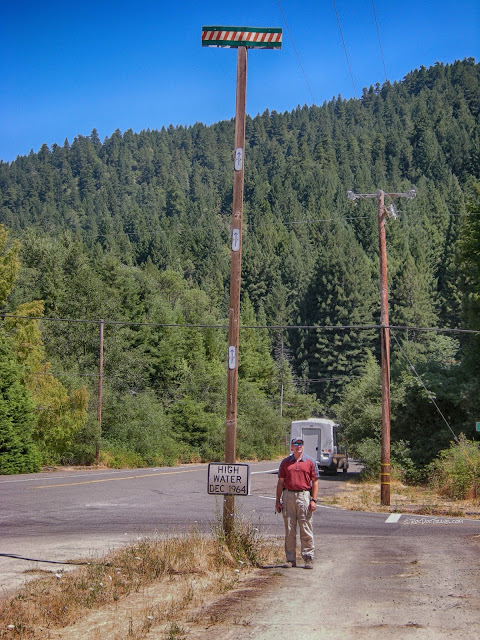
The "Christmas Flood" of December 1964 in northern California caused the Eel River to have a discharge of 936,000 cubic feet per second (26,500 cubic meters per second), which is equal to the normal flow of the Mississippi plus Columbia rivers combined! That made it the largest river in North America! The flood wiped the town of Weott off the map, and every other riverside town in northern California was heavily damaged. 80% of the mountain roads were damaged. The flood resulted from an "ArkStorm," an atmospheric river of tropical moisture that occasionally strikes the West Coast. A mild version of an ArkStorm is commonly known as "the pineapple express" because it brings moisture from near Hawaii. A flood this big is expected to happen again! The geologist is Ben Jordan. Field Trip: Northern California CoastThe photo above was taken on Avenue of the Giants at the access road from upper Weott.
From Giant Peak to Crater Lake, Oregon
Mt. Mazama, the volcano that exploded catastrophically to form Crater Lake 7700 years ago, was likely the biggest of the Cascades volcanoes at nearly 15,000 feet. The eruption put several feet of ash across the West, and created North America's deepest lake at nearly 2000 feet (nearly 600 m). That means the lakebed is about 10,500 feet (3200 m) lower than where the peak was! Field Trip: Crater LakeOlder Volcanoes at Yellowstone, Wyoming
Yellowstone wasn't the first volcano in the neighborhood! Its volcano formed adjacent to an older volcanic field. The 45 million year old Absaroka Volcanic Field occupies the National Park's eastern side, and covers 9000 square miles (23,300 square km). This view is from the southern Beartooth Mountains looking westward at Pilot Peak near the Park's northeast entrance. The peaks are made of Absaroka volcanic rocks. Field Trips: Yellowstone, Yellowstone East, Beartooth HighwayAn Aquifer Waterfall, California
Burney Falls pours out of a river and an aquifer! In the picture, the river is the highest part of the falls. Below the river, water flows through gravels and between lava flows. Where the stream eroded out a waterfall, the aquifer joins in the fun. The scenic falls are a state park located just north of Lassen Peak in northeastern California. Field Trip: Burney FallsThe Big One: Island Park, Not Yellowstone
Yellowstone's biggest eruption was not from inside the park! It was from Island Park next door in Idaho. The eruption put 2500 cubic kilometers of volcanic rock into the air 2.1 million years ago, likely causing an ice age. Island Park is the only place in the Yellowstone region where you can see much of the caldera rim because the caldera in the park has been filled up by younger lava flows. When you stand in the middle of Island Park, you can see more than half of the caldera rim surrounding you. The photo was taken at Big Springs on Henry's Fork of the Snake River. Field Trips: Island Park, Yellowstone RegionCape Mendocino Triple Junction
Cape Mendocino on the northern California coast is a tectonic triple junction! The Pacific, North American, and Juan de Fuca plates all meet here. As a result, this area has frequent earthquakes, and the bedrock is intensely deformed. Just offshore from this spot is the north end of the San Andreas fault. Field Trip: Northern California CoastCalifornia Oil
Did you know that California has some of the continent's biggest oil fields? Did you know that the Los Angeles Basin contains more oil by volume than any other sedimentary basin in the world? California's major oil-producing rock, the Monterey Formation, is exposed along the coast. More oil has seeped from it naturally than all the man-made oil spills along the coast combined. The tar you may see along the California coast is natural! This picture of the Monterey Formation was taken at Montana de Oro State Park near Morro Bay. Field Trip: Central California CoastGiant Wyoming Landslide
One of Earth's biggest landslides is just east of Yellowstone! The Heart Mountain detachment covers over 500 square miles (1300 square km) in the area west and northwest of Cody, Wyoming. The landslide is thought to have occurred about 42 million years ago when the Beartooth Mountains were uplifted and earthquakes caused an extensive sheet of sedimentary strata to slide downward and out across the basin surface.Heart Mountain is located north of Cody, Wyoming. The cliff-forming limestone at the top is a Mississippian (360-320 million years ago) limestone that slid across the Bighorn Basin ground surface to where it is today. Erosion has removed all of the landslide here except the one patch of limestone. Field Trips: Yellowstone East Entrance, Cody Wyoming
Coral Reef Mountains, Texas and New Mexico
The Guadalupe Mountains on the Texas-New Mexico border are not uplifted fault or fold mountains, they are an ancient reef! The topographic relief you see there today is the shape of the reef. Softer sediments that filled the ocean floor below the reef have more recently been eroded away, leaving the more resistant reef standing high. Guadalupe Mountains National Park and Carlsbad Caverns National Park are fascinating places to see a lot of fossils. Field Trips: Guadalupe Mountains National Park, Carlsbad CavernsA Big Dam Failure
The Teton Dam in eastern Idaho is the tallest dam ever to fail in the world! Here's a surprising link: a major reason the dam failed is because of Yellowstone - it's built on the Huckleberry Tuff, which is the volcanic ash erupted from the hot spot's biggest eruption 2.1 million years ago. When volcanic tuff cools and hardens, it fractures. The fractures form a 3-D honeycomb that allowed water to flow around the dam and erode it from the side, leading quickly to the dam's failure. Field Trip: Teton DamBanff's Ocean
The limestones that form the beautiful cliffs in Banff National Park were formed on the continental shelf! They were later shoved landward by collisions with islands and parts of the Pacific Plate's ancestors. The region was later uplifted and eroded, exposing the ancient sedimentary rocks, faults, and folds. Field Trips: Banff South, Banff Part 1, Banff Part 2. This fold is in the center of the map below.Giant Faults at Death Valley
The "turtlebacks" in Death Valley are fault scarps! The mountainside in this view is about 2500 feet (830 m) tall, and the bedrock is polished and sheared from movement on the fault. Field Trip: Death ValleySantorini Gave Us Europe and America
The eruption of the Santorini volcano, Greece, in about 1600 BC led to the downfall of the powerful, mysterious Minoan civilization! As a seagoing people heavily dependent on ship-born trade, the tsunami caused by the eruption destroyed many ships and ports, including those on their home island of Crete. If the Minoans had remained in power, then perhaps the Greeks and Romans would never have arisen, and the West's entire history would have been drastically changed! I wouldn't be writing this in English, for example, and the West would probably not have democracies. All this from a volcanic eruption! Field Trip: SantoriniHalf Dome - Not!
Half Dome in Yosemite National Park isn't half of anything! It's just a block of granite with less fracturing than the surrounding granite. Ice and glaciers destroy and carry away fractured bedrock, leaving behind solid blocks like Half Dome. Field Trips: Yosemite Valley, Yosemite Up HighInside a Reef
Carlsbad Caverns in New Mexico are inside an ancient reef! The caverns were eaten out by slightly acidic groundwater. The walls, floors, and roof are chock-full of fossils. Field Trip: Carlsbad CavernsVolcanoes at Napoli, Italia
Naples, Italy, is built next to a series of potentially active volcanoes! Vesuvius is the obvious one, but the hills from near the city center west to Lago del Fusaro are the remnants of volcanoes, and they have recently shown signs of life. The city has a real risk from volcanic eruptions! Field Trips: Vesuvius, Pompeii, HurculaneumGiant Vaiont Landslide, Italy
The enormous Vaiont landslide in the Dolomite Mountains of northeastern Italy is one of the biggest and deadliest landslides of modern times! At over a mile wide, it has a volume of over 260 million cubic meters. The landslide occurred when a reservoir was filled behind Europe's tallest dam, the Vaiont, and high water pressure caused the bedrock to become weak and collapse (the same phenomenon behind hydraulic fracturing, or "fracking"). The landslide occurred at about 10:30 pm, and pushed all the water out of the reservoir and over the dam, killing more than 2000 people in Longarone and other towns downstream. Field Trip: Vaiont DamMt. Rainier Cooks Itself
Mt. Rainier near Tacoma, Washington, is corroding itself from the inside out! Magma not far under the volcano heats groundwater to supercritical temperatures, causing it to rise into the volcano. Such hot water is effective at dissolving the volcanic rocks, turning them into soft clays. Because hydrothermally corroded rock is soft and weak, the mountain experiences periodic massive landslides and lahars. (A lahar is a mudflow or debris flow from a volcano). Lahars pose the greatest risk from Rainier because they are more likely than an eruption! Field Trips: Rainier, Rainier SunriseSubduction Zone in the California Desert
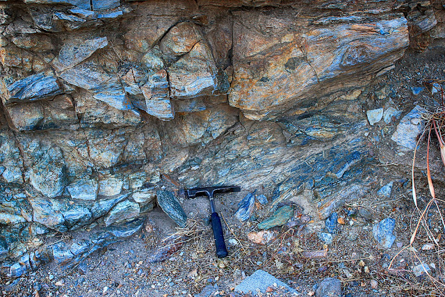
The Rand Mountains of southeastern California contain an ancient subduction zone! The blueschist rocks shown here started out as oceanic crust basalt, and were metamorphosed to blue deep in the subduction zone where plates collided. The plate boundary later shifted farther west, stranding this section, and later deformation caused it to be uplifted and exposed in the Rand Mountains.Why San Francisco is Falling Apart
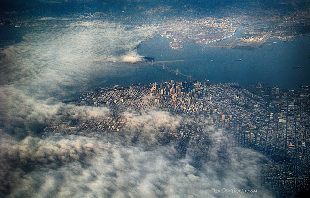
The city of San Francisco is built on an old subduction zone! That means the bedrock is mostly weak shale and jumbled metamorphic rocks that originated on the ocean floor or deep in the wet boundary between tectonic plates. With so much clay and no structural stability, the ground is highly susceptible to landsliding. Civil engineers take special training just to build anything here. Field Trip: San Andreas in the San Francisco AreaShove It, Nevada!
In the area surrounding Las Vegas, the dark rocks shown here by Valley of Fire State Park were shoved over 50 miles over the reddish rocks below! So were the dark rocks above the cliffs at Red Rocks State Park. Between about 70 and about 140 million years ago, North America collided with islands and pieces of the Pacific Plate's ancestors. A thrust fault formed on top of the sturdy Aztek Sandstone, the bedrock of both state parks and Zion National Park in Utah. Rocks along the fault are highly fractured and sheared. Field Trip: Buffington Window, NevadaRise of the Grand Canyon
The Grand Canyon formed when the land rose around the river! The Four Corners and Rocky Mountain regions began slowly rising about 5 million years ago, so slowly that the Colorado and Green rivers easily eroded downward to maintain their stable profiles. Gradually, the Colorado captured other rivers and turned them down its channel. The process explains the meandering patterns in the river channels that are now deeply entrenched in the bedrock, and explains why it's downhill in all directions from Grand Canyon National Park (the park is at the center of a broad uplift that rose around the river). Field Trip: Grand Canyon South RimKeep exploring this amazing Earth!


