12 Cool Geologic Sites, Western U.S.
12 Cool Geologic Sites, Western U.S.
This is another collection of photos of great geologic sites that don't fit into other field trips. This collection is from Montana, Oregon, Washington, and California.
To show coordinates on a map, copy and past the coordinates given here into the query window in Google Maps or your favorite mapping program.
Pioneer Mountains, SW Montana
These gorgeous glaciated peaks are located along I-15 northwest of Dillon. This photo was taken on the east side. The core peaks are a Cretaceous (170 to 65 million years) granite that may have been decapitated from the Idaho batholith farther west, and thrusted tens of miles eastward along a nearly horizontal fault. The adjoining Paleozoic to early Mesozoic strata on the east side of the mountains are folded into numerous anticlines and synclines that are visible in aerial photos like Google Maps.Interactive Google Map
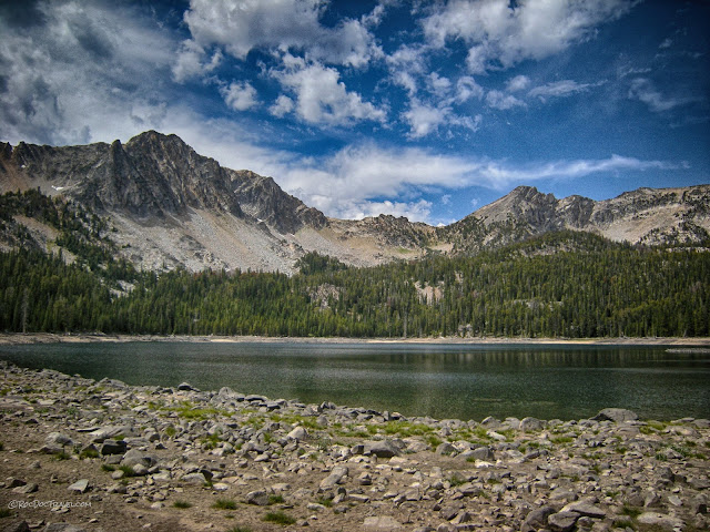
East side's Birch Creek (accessible from I-15) has fantastic mountain scenery. If you're a serious off-roader, the western several miles are a great challenge with a huge reward - Pear Lake (45.424888, -112.995089) in a glacial cirque right below the highest peaks.
Pear Lake in the Pioneer Mountains.
On the north side, Canyon Creek Road and Quartz Hill Road will take you high onto the mountains' shoulders where you'll find the Quartz Hill mining ghost town (45.715759, -112.898587) with a few cabins and a mine headframe. State Road 73, a scenic byway, crosses the central range from north to south along the gorgeous Wise River. There are several good Forest Service campgrounds along the river. Near the road's south end is Crystal Park, (45.486652, -113.099807) where for a small fee you can dig for quartz crystals. The Maverick Mountain ski area is a little farther south.
Lost Creek Canyon, Montana
In western Montana, Lost Creek Canyon is an important geologic site because it exposes a "syntectonic granite" - that is, a granite that intruded into the actively moving thrust belt during the Cretaceous period. This picture shows the granite, which exhibits exfoliation, the tendency for crystalline rocks to peel off in sheets after they have been exposed at earth's surface. Here and at Yosemite, the crystalline rocks have been uplifted by many kilometers, which causes them to expand slightly, and they break apart in sheets. The granite intruded into one of North America's thickest sedimentary basins, the Proterozoic Belt Supergroup that is 1.7 to 1.0 billion years old.We know the granite intruded into active thrust faults because it follows them and has shear fabrics formed while partially molten. There is no one place to see all those relations, just by mapping out the granite throughout the canyon.
The canyon is located by Anaconda not far from I-90, and is a state park with a nominal fee and a campground.
Interactive Google Map to Lost Creek Canyon, Montana
The granite in Lost Creek Canyon has fascinating erosional features, like this exfoliation surface smoothed by water and ice.
The striped rocks shown here are the Belt Supergroup, which is mostly metamorphosed sandstone and siltstone deposited in a rift valley at what was the western edge of North America at the time of the first super continent, Rodinia. The Supergroup is between 15 and 20 km (9 - 12 miles) thick, which means it makes up nearly half of Earth's crust here! See the granite dike cutting across the metasedimentary rocks?
This photo nicely shows exfoliation of the granite in Lost Creek Canyon.
Mount Hood, Oregon
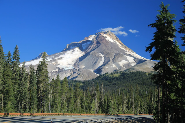
Located conveniently east of Portland, Oregon, is one of the Cascade Range's most beautiful volcanoes. Occasional small earthquakes indicate that there is active magma beneath the volcano. Its last eruption was a small one in the 1790's shortly before Lewis and Clark passed through - they could still see evidence of ash in Sandy Creek. I find it thought-provoking that we have gotten so comfortable with this volcano that we invite crowds to ski on it.
Mount Hood from highway 35 on the east side. Look closely at each stream or drainage you cross - devastating floods and debris flows are common in all the drainages off Mt. Hood.
These are photos in the state's Mt. St. Helens visitor center located just east of I-5. These are the only photos I know of that really show the horizontal eruption that occurred on May 18, 1980. The climbers are on Mount Adams. Mt. Saint Helens, Washington
Also see my St. Helens field trip.
Death Valley National Park
When you visit Death Valley National Park, you kind of expect to see a scene like this - a dust storm blowing sediments off the dry lakebeds and toward the sand dunes. I'll have a complete field trip to Death Valley coming up soon.From a geologic standpoint, Death Valley is a very young and very active feature. This smooth slope is a fault near Mormon Point. The bedrock has been sheared and polished smooth, and the extremely dry climate has preserved it well. Pieces of gravel remain where they were deposited on the fault, left by the quirks of differential erosion.
The Furnace Creek Inn is a top-tier resort in Death Valley, not far from the low point at Badwater. I've enjoyed its facilities, and can highly recommend it. You can also stay at the The Ranch at Furnace Creek, more affordable accommodations near the national park headquarters.
Crescent City, California
The lighthouse at Crescent City warns ships of the rocky, shallow coastline. It's this shallowness that makes Crescent City prone to damage from tsunami, like the ones in 1964 and 2011.California golden poppies, my favorite flower. Nothing compares to the unique color of the state flower. Yes, even geologists take time to smell the flowers!
A Meandering River in Canada
Meandering river, southern Canada. I always get a window seat when I fly so I don't miss sights like this. The river has abondoned its wider loop by cutting through the narrow neck. Meandering rivers are difficult to live with because they change course over time, sometimes suddenly during floods. A mistake that pioneers made, and usually lived to regret, was building towns near such rivers. Their floodplains are often wide, and the river will at some time fill them brim to brim.Mattole Road and Petrolia, California
Landslides along Mattole Road south of Ferndale, California (40.419453, -124.398785). The road is rarely traveled, yet is as scenic as any in California. It's narrow, rough in places, and tight and steep in places, so I don't recommend RV's or very low sports cars try it. Landslides are common here for two major reasons - first, the bedrock includes shaly, unstable layers that were accreted onto the continent from the seafloor, and second, earthquakes are frequent here.
The Mattole Road is the only road to Cape Mendocino, another auspicious geologic site because it is the triple junction between the North American, Pacific, and Juan de Fuca tectonic plates. This area has frequent and large earthquakes as a result.
Eel River, California
High water mark at Weott, California, from the great flood of December 1964 (coordinates 40.325090, -123.926090). The town was completely wiped out, and moved to higher ground. Highway 101 was also moved in many locations after this flood illustrated just how high the water can get in a phenomenal storm. The state spent a lot of money and effort, and continues to do so, to make these northern roads more storm-resistant because they are lifelines to the mountain communities. The geologist is Ben Jordan.
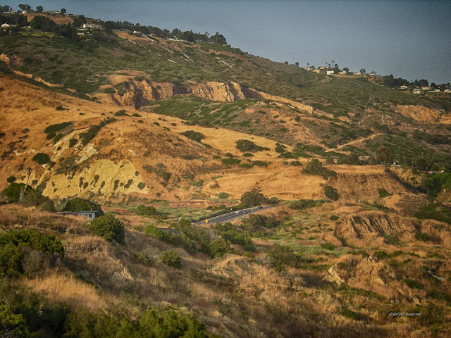
If you're ever in the Los Angeles area, swing by the Portugese Bend landslide complex (33.740339, -118.361820). It's on Palos Verdes Drive South west of San Pedro. The slides have been moving for decades, so frequently that the road has one of my favorite signs ever: Palos Verdes Landslides, California
!
Owens Valley and Whitney Portal, California
The Owens Valley fault scarp formed during the big Lone Pine earthquake of 1872. Being that old, the magnitude isn't exactly known, but based on damage, fault rupture length, and eyewitness descriptions, it may have been greater than M7.5. The scarp is in boulder alluvium. The best place to see the scarp is just outside of Lone Pine off the Whitney Portal road at these coordinates: 33.740339, -118.361820. You'll have to take some dirt roads to get there, but they're passable by most sedans.Whitney Portal is, as the name suggests, the trailhead for the hiking trail to Mount Whitney, the highest point in the contiguous U.S. It offers tremendous views of the Sierra granite and its exfoliation features (explained with Lost Creek above). Just as in Yosemite, the granite is expanding, causing great sheets to break off. Rockfalls are frequent, and are a major hazard throughout the Sierra in all the steep canyons. The trailhead and campground are located here: 36.587100, -118.240108 .
I took these pictures in the last week of May! Expect weather extremes when you're in the high Sierra.
To see related posts, go to the main page and scroll down to find the applicable label from the list on the right side of the window.


