Craters of the Moon National Monument, Idaho
Craters of the Moon National Monument, Idaho
Visit America's best preserved volcanic features at Craters of the Moon National Monument in the middle of Idaho -- cinder cones, spatter cones, fissures, tree molds, pahoehoe and a'a lava flows, and of course awesome lava tubes! There's something for everyone!Why Visit Craters of the Moon?
Craters of the Moon National Monument, Idaho, is located along the northern edge of the Yellowstone hot spot track on the Snake River Plain. With eruptions as young as 2000 years, it is one of the most likely places to have another eruption outside of the Cascades -- more likely than Yellowstone! The dry climate of Idaho has preserved the volcanic features here better than just about anywhere else. A visit to Craters of the Moon makes a terrific add-on to your trip to Yellowstone or central Idaho.View to the south of the Monument from Google Earth, with ages of the volcanic rocks in years. The fissures and cinder cones here have been erupting for tens of thousands of years, and have a very real possibility of erupting again.
Travel to Craters of the Moon
Location: On America's longest highway, U.S. 20 in the middle of Idaho.Lodging: Camping & RV spaces are available at the Monument. Small motels and a KOA are available in Arco, about 20 miles to the east. The most abundant motels are in Idaho Falls and Pocatello. Higher-end lodging is available to the west at Hailey - Ketchum - Sun Valley, about an hour drive.
Driving Times: Boise: 2:45 Ketchum: 1:15 Pocatello: 1:35 Idaho Falls: 1:30 Arco: 0:20 West Yellowstone: 3:00 Rexburg: 1:45
Food: Bring your own food and water! Only vending machines are available on-site.
Logistics: Fill your gas tank before heading out because gas stations are at least 20 miles from the park. This is a good trip to combine with one to Sun Valley, the Sawtooth Mountains, or even Yellowstone (if you're coming from the west).
Vehicle: Any. Everything is paved, and there are no steep grades.
Seasons: At elevation over 5000 feet, Craters is limited in the winter except some cross-country skiing and snow shoeing. With all the black rock, it gets warm in mid-summer with temperatures sometimes in the 90's F.
Hiking: The Monument offers a variety of trails, most of which are easy. Visit their website for more information.
Considerations: Take plenty of water, sunblock, a hat, and decent hiking shoes. Be prepared for wind.
Park Website: Click Here. Entrance fee is currently $10 per vehicle.
Craters of the Moon Geology
See my Volcano Primer for basic terminology and rock types.
Google Earth view looking north. The visitor center and Highway 20 are along the north end of the Monument. Lava flows have spread out mostly from there, with a few more southerly origins.
The broad Snake River Plain is the Yellowstone hot spot track. For about 17 million years, North America has been sliding southwestward over a strong source of heat in the mantle. That heat resulted in magma formation in the crust and a series of volcanoes and calderas (volcanoes that collapsed in gigantic eruptions), the youngest of which is Yellowstone. Craters of the Moon formed over a pool of magma in the crust left over from passage of the hot spot. Geophysical studies show that there is still magma under the Monument, about 10,000 feet down.
Panorama of the north end of the park, viewed from near Highway 20. The cinder cones in this picture are between 2400 and about 6500 years old. The older a volcanic rock is, the more vegetation grows on it. That means you can estimate the ages of the rocks here -- the barest lava flows and cinder cones are the youngest ones.
Silent Cone's exact age isn't known, but is estimated to be about 6500 years based on relationships with other features. Sometimes radiometric dating methods are not able to find clean, unaltered minerals with the right isotopes to get a date from.
We use the Hawaiian term for jagged, blocky textured lava, "a'a." In Hawaiian words, you pronounce all vowels separately, so this is "ah-ah."
On one trip to Craters of the Moon, I went with my son's 4th grade class. That's a sure way to keep a scientist humble! The kids asked questions and made observations that had never occurred to me, and it was challenging to answer them using words they would understand. I hope that using my field trips, you can teach your kids and friends more than just "it's pretty." The world is a lot more interesting when you know something about it!
The house-sized chunks of lava in this view are pieces of the cinder cone that collapsed and were carried like rafts on the lava flow.
The sign explains the "rafts." The middle one in this picture is about 9 meters tall!
View of 2076 year old lava flows from the North Crater.
View from the North Crater toward the visitor center.
This is the Big Craters cinder cone, one of a series that formed along a fissure. Magma rises through the crust along cracks, or fissures, because they are the easiest path. When the magma gets close to the surface, it opens the fissure at the earth's surface, creating a curtain eruption that eventually plugs up to become one or a few cinder cones.
These two spatter cones formed along the same fissure as the Big Craters.
Spatter is blebs of lava that are still liquid when they hit the ground, so they melt together. Yes, "blebs" is a real scientific term! It's a big liquid drop.
What could possibly be in there?
The kids were looking at the inside of the spatter cone. When the squirting stopped abruptly, it left a deep hole.
You can see by this texture that the spatter was liquid when it was tossed through the air and hit the ground.
Because flowing lava chills and hardens when it's in contact with the air, it quickly becomes sealed in by a hard roof and flows in tubes underground. When the lava supply is stopped or diverted, the lava flows out of the tube, leaving it empty. Tubes range in size from a few centimeters to more than 10 meters across.
Google Maps view of the lava tubes. You can just see the walking path. The holes are where the tubes have collapsed. These formed in a lava flow only 2076 years old!
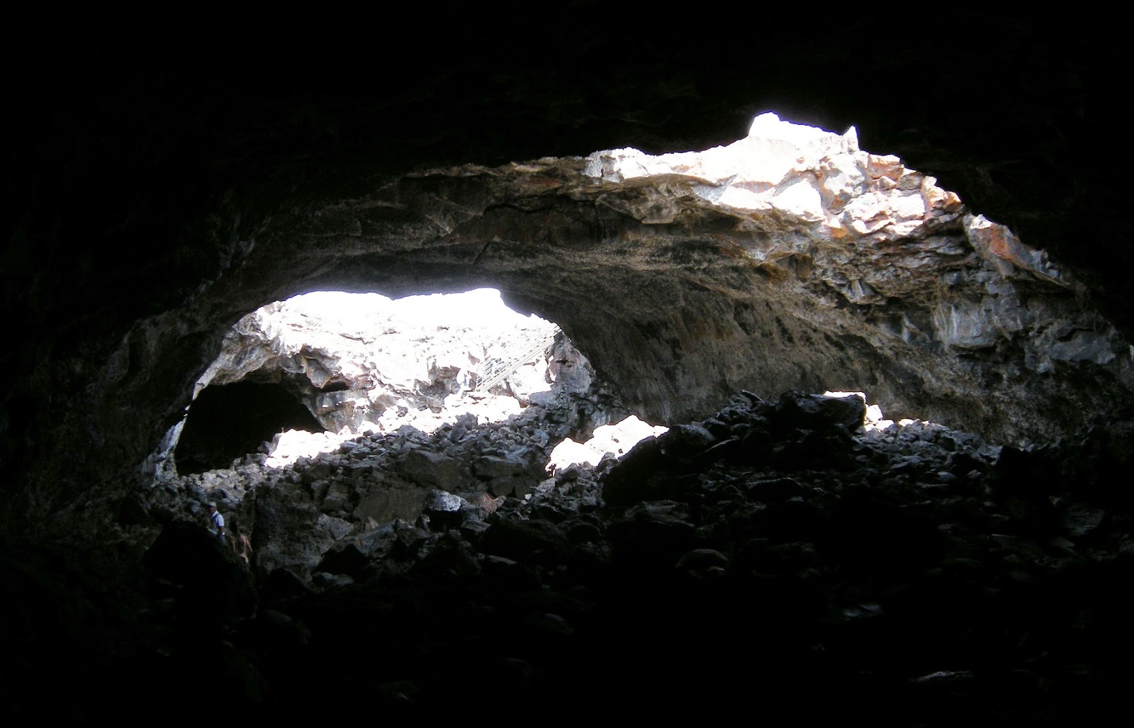
We enter lava tubes where they have collapsed, creating an entrance.
Take a flashlight with you! Parts of the lava tubes are dark.
The tubes are pretty shallow, but looking back toward the light makes you realize humans aren't meant to be underground!
This is a skylight. They form while lava is actively flowing in tubes, too. Note the person at right for scale.
Because volcanic rocks shrink when they solidify (like all liquids do, except water), they fracture and aren't structurally sound. All those rocks on the floor came from the ceiling! Note the people for scale.
Note the kids for scale. These tubes are incredibly large!
In the walls of the tubes, we can read the history of the lava. This horizontal bench was created by lava flowing at that level in the tube. The layers above show a relatively complex history of flow layering.
This is a look back toward the entrance. Note the people at left for scale.
Along the trail is an example of a small lava tube. You'll see these throughout the Monument.
Summary: Craters of the Moon has something for everyone. It's a great add-on to any trip to the region, especially Yellowstone or the Sawtooth Mountains. It's a picnic or camping trip because of limited on-site facilities, and so takes some preparation and planning. But it's worth it because of the fantastic volcanic features preserved here like nowhere else!
Related Posts: With the Yellowstone or Volcano or Idaho labels.
Geologic Map of the Park: Click Here.


