The San Andreas, San Francisco Area
San Andreas Fault, San Francisco Area
Take a day trip to see California's most famous geologic feature in the San Francisco area!Why Visit the San Andreas Fault?
The San Andreas fault is one of the rare places on earth where you can see and touch a tectonic plate boundary. Most are under the oceans, but this one is right in Northern California's back yard! To see another as distinct as this, you'd have to go to New Zealand, Iceland, Israel, or Turkey.On this trip, the scenery alone is worth every penny!
Travel to the San Andreas
Time: 1 day for all the sites, but it can be broken into parts for shorter trips.Difficulty: Easy for all.
Logistics: Traffic in the Bay Area is the main concern. Highway 1 north of San Francisco can be busy on weekends and holidays. RV's and long trailers are not allowed at the Battery (near south end of the Golden Gate) and on Highway 1 to Stinson Beach.
Lodging: If you don't live in the area, I recommend staying near the south end the first night and near the north end the second night. South end options include Hollister, Watsonville, and even Monterey or Santa Cruz. North end options include Point Reyes, inns along Highway 1 (very cool!), and inland at Petaluma.
Options: You'll be near some awesome hiking areas, especially at Marin Headlands, Point Reyes, and Mount Tamalpais. These are truly unique and awe-inspiring hikes. Mount Tam has marvelous redwood forest and unequaled views over the SF Bay. The hike out to Tomales Point is a great ocean-side experience.
Geology of the San Andreas
This is world-class geology! The San Andreas is a transform plate boundary, which means that the two plates move horizontally past one another. The Pacific plate is moving northwest, while the North American plate is moving slowly west-southwest. The resulting relative motion between them is directed north-northwest. Transform faults also link two different kinds of plate boundaries -- in this case, the divergent East Pacific Rise in the Gulf of California with the convergent Cascadia Subduction Zone that starts off the northernmost coast of California.The west side of the fault moves about 1-1.6 inches (2.5 to 4.0 cm) northward every year. Eventually L.A. will be a suburb of San Francisco - or is that the other way around? It also means that in the past, the rocks on the west side of the fault were much farther south, and that means that in many places the two sides of the fault are very different from each other. I'll show you those places in the San Francisco area.
(Above) The San Andreas fault joins a divergent plate boundary to a convergent plate boundary -- the East Pacific Rise to the south with the Cascadia Subduction Zone to the north. Google Earth image with USGS fault locations and my annotations.
Until about 17 million years ago, the Pacific ocean floor was subducting under California. That formed a chain of volcanoes whose roots we see today as the Sierra Nevada mountains, and a thick wedge of rock and sediment that was plastered onto North America that we see today as the Coast Ranges. In this trip, I'll show you the former seafloor material the Coast Ranges are made of.
(Above) A strike-slip fault like the San Andreas makes distinctive features in the landscape, as shown in this U.S. Geological Survey diagram. I'll show you some of these in this field trip.
Downloads
You can download Google Earth .kmz files of faults in the U.S. from the US Geological Survey HERE. That file will allow you to see faults wherever you want. Google Earth must be previously installed on your computer. Download it free HERE.I'll describe the fault from south to north.
San Juan Bautista
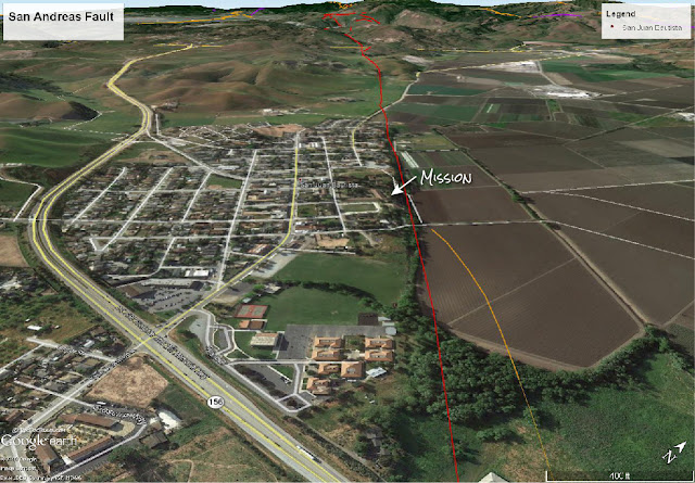
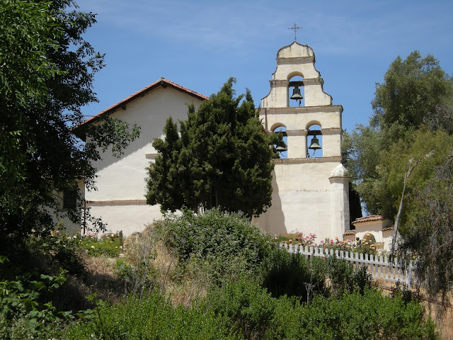
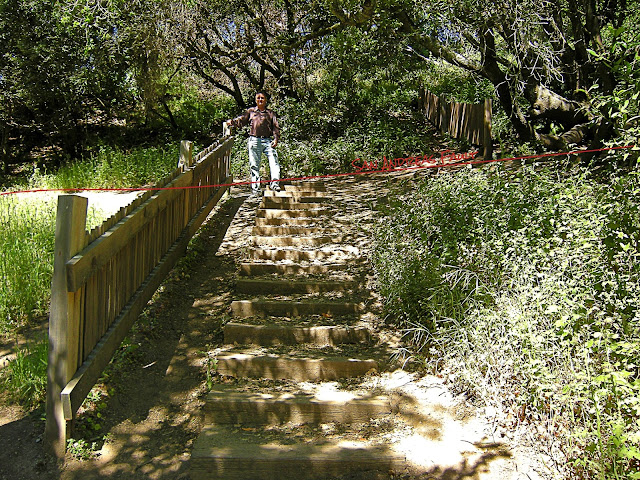
This town marks the southern end of the San Andreas fault's rupture in the 1906 earthquake. The old mission was heavily damaged. The bell tower you see today was built after the earthquake. The mission and surrounding historic buildings are a beautiful place to visit. There's even a sign telling about the San Andreas, and you can walk along the fault on the old Camino Real. It's below the mission at the edge of the hill. That straight edge is one of the tell-tale landscape features of the fault, because only faults make straight lines in nature.
(Above) A Google Earth view of SJB, showing the fault. Fault location from USGS, with my annotations.
(Above) Interactivie Google Map of SJB.


Geology Along The Santa Cruz Highway
The next spot to see the San Andreas is on the Santa Cruz Highway. Highway 17 to Santa Cruz crosses the San Andreas a mile south of Lexington Reservoir just north of the big bend. Southbound, it's near the "Slow Trucks" sign. Northbound, it's near the end of the long guardrail at the wide shoulder, and before the "50 mph" and "Call 511" signs. This place doesn't look like much until you consider how unusual the distinctly straight valley is. It's worth the time to get out and compare the bedrock on the two sides. You'll see that they are vastly different.
Big Basin Way (Highway 9)

San Andreas on the San Francisco Peninsula
The San Andreas fault is easily visible on the west side of I-280 from about Farm Hill Blvd. by Canada College north to where highway 35 (Skyline Blvd) takes off. It's marked by a long line of straight valleys and a distinct change in landforms and vegetation. Because the bedrock west of the fault is more solid and competent than that on the east side, the hills are a little steeper and higher and have more vegetation than the east side.

(Above) Highway 92 cross the San Andreas in the middle of Crystal Springs Reservoir. A little farther north is San Andreas lake, the fault's namesake.
(Above) Interactive Google Map so you can find the Crystal Springs dam.


(Above) I took this picture so you don't have to brave the traffic on this narrow road (please don't try it!). It's from the shoulder of Highway 92 where it crosses the San Andreas in the middle of the reservoir.
Mussel Rock

(Above) View looking south. The fault goes offshore at Mussel Rock. Google Earth image with USGS faults.
(Above) Getting to Mussel Rock is a little tricky. Follow the map carefully. I like to take Skyline to Manor Drive (you won't believe how steep it is!) and across Highway 1 to Palmetto. Manor Drive is NOT suitable for RV's, so instead take Sharpe Park Road from Skyline down to Highway 1, go north, and then left on Manor Drive to Palmetto.


(Above) Geologically speaking, an ocean view usually comes at a price. The hills here are ancient shoreline sand deposits, and are not very solid. The bare areas are recent landslides, and the vegetated areas are older landslides.

(Above) The bare scarps are the tops of recent landslides. Among geologists the motto is, "once a landslide, always a landslide" because they repeat in the same location over and over until the entire hill is reduced to a gentle slope. Another give-away of landslides is the lumpy topography here.


San Andreas Geology at San Francisco
To get to the Golden Gate Bridge from Mussel Rock, I suggest taking Skyline Blvd. north to Great Highway along the beach. Past Cliff House, turn left onto El Camino Del Mar and immediately right on Seal Rock Drive. Turn left on 34th Street and go through the Lincoln Park golf course and past the Legion of Honor Museum (a must-see!). Turn right on Lincoln Hwy / El Camino del Mar and follow it to Overlook Parking in the Eucalyptus trees. You can also turn on Merchant Rd. for more parking (see map below).NOTE: Long RV's, trailers, and buses are not allowed on El Camino del Mar, but you can come in from the east on Lincoln Blvd. through the Presidio (another gorgeous drive!).
(Map) The melange landslides shown here are located off Lincoln Blvd at the Batteries, near Merchant Drive.

To get to the Golden Gate Bridge, take Lincoln Blvd east under the freeway, then left at the brown sign to the bridge.
Marin Headlands
Just north of the Golden Gate bridge, take the Alexander Avenue exit and turn left, back under the freeway to get to the Marin Headlands roads.
Take a look at this Gigapan image of the bridge, which I took from the Marin Headlands: Gigapan Try zooming in! Several more (and better!) of this area are available at Gigapan.com.
Stinson Beach
To get to Stinson Beach from Marin Headlands, you have to get back on the freeway and go north to Highway 1 exit at Tamalpais Valley. The road is very winding and locally steep, so don't plan on taking any long RV's or trailers. You can get to Highway 1 with RV's by using roads farther north.
(Above) Use this interactive map to find your way to Stinson Beach. From here, you'll continue north on Highway 1 to Point Reyes.
Point Reyes

(Above) The Point Reyes visitor center is on Bear Valley Road just north of Olema. Watch for the brown signs for the turnoff.


(Above) The pillow lavas are at Laurel Canyon Road by the sign for Golden Gate National Recereation Area.
(Above) Google Maps Street View of the pillow lava.


(Above) Tomales Bay formed along the San Andreas.
A great way to end your trip is dinner at one of the great seafood places on Highway 1 along Tomales Bay like Nick's Cove, or Hog Island Oysters, or Marshall Store, or Tony's Seafood, or get oysters to shuck at Tomales Bay Oyster Company.
Related Posts have the "San Andreas" label. Other trips along the northern California Coast are also available -- click on the "California" label.
California cannot "fall into the ocean." In fact, the coastal mountains are slowly rising higher above sea level. You can see the evidence in the terraces along the central and northern coast that are old beach levels, now lifted high above the waves.
M.S. -- More Science
National Park Service: http://www.nps.gov/pore/learn/nature/faults.htm
Visit http://scedc.caltech.edu/recent/index.html to see recent earthquakes in California and Nevada, and browse their other pages for lots more information.
Good summary of the San Andreas: http://pubs.usgs.gov/gip/earthq3/
Better in-depth document: http://pubs.er.usgs.gov/publication/pp1515
Better in-depth document: http://pubs.er.usgs.gov/publication/pp1515
You can also do a web search like this: "san andreas" site:usgs.gov
==============================================
California fault earthquake geology travel trips fieldtrip roadtrip San Andreas
All images have copyright notice in the metadata except those from the USGS.


