Rainier: Paradise
Mt. Rainier -- Paradise
At 14,409 feet, Mt. Rainier has more glaciers on it than any other mountain in the continental U.S.
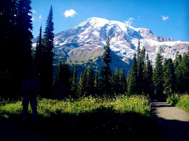
(Above) Rainier from the south. If you're fortunate enough to visit on a cloudless day, Rainier will suddenly loom out of the forest in its massive glory! First impressions are often, "Wow, it's sooooo big!"
This trip will help you interpret what you see at Paradise.
Why Visit Rainier?
Rainier is probably the most dangerous volcano in America, as well as one of the most beautiful mountains. The volcano is deeply glaciated, holding 27 glaciers that cover 35 square miles and feed 6 major river systems -- no other mountain comes close. The old-growth forest in the national park is serenely breath-taking, and will make you want to stay forever!Natural Hazards at Rainier
Rainier is dangerous because it looms over large population centers at Tacoma and Seattle. It's dangerous because history shows it doesn't have to erupt to cause destructive landslides and lahars (debris flows with the consistency of concrete) that have raced all the way to the Puget Sound. It's dangerous because it holds billions of cubic meters of ice in its glaciers, which if melted could create enormous floods down one of its river valleys. It's dangerous because there is a body of magma inside the peak that is steadily rotting the mountain from the inside out by circulating corrosive hot water through the rock.Interactive Google Map
Travel to Rainier National Park
Getting There: Rainier is accessible from any direction, but this trip will focus on the Paradise visitors center area on the south side of the mountain (see map). The road up is windy and steep in places, so be prepared. It is open to RVs, but please be sure your vehicle and its brakes are in good condition.Road Status: Road Status The road from Longmire to Paradise is open year-round, but check this link when the weather is questionable. Chains are often required.
Difficulty: Easy for anyone if you stay by the visitor center, moderate if you hike to the Nisqually overlooks (highly recommended!). More strenuous hikes are readily available from Paradise, including expert-only and guided climbs to the summit.
Time: A day is sufficient to see Paradise. Add additional days for Sunrise and the wonderful old-growth forest in the park.
The Paradise Visitor Center has all amenities, including good food. It also has good descriptions of the mountain's history, hazards, and glaciers. It's the best place to start.
The Geology of Mt. Rainier
Mt. Rainier started erupting about 500,000 years ago, forming a broad blanket of pyroclastic flows (explosively erupted avalanches and air-fall). You can see this broad plateau from the mountain or any distant view. Note how the younger cone sits on top of the plateau. The volcano went through several phases that eventually formed the composite cone we see today. The date of the last eruption isn't very clear, but appears to have been pyroclastic flows and lahars (mudflows) about 1000 years ago. There may also have been steam explosions in the 1800's.See my "Volcano Primer" page to learn the rock types and features you'll see at a volcano.
Lahars are the most immediate hazard of Mt. Rainier. A lahar is a debris flow from a volcano -- essentially a flood of rocks and concrete-like mud. They can travel 45 miles per hour, and will remove anything in their path. Past lahars have flowed all the way to the Puget Sound and covered broad areas (see map below).
(Above) Map of past lahars from Mt. Rainier. More lahars will happen in the future -- it's only a matter of when. (USGS image)
Geology Along Rainier's Roads
Visit every scenic turn-out you encounter! The next 2 photos were taken at the high bridge across Nisqually Creek.On the drive up from the west, you'll cross Nisqually Creek, which drains the Nisqually glacier complex that you'll see at Paradise. The big rocks are a clear indication that this valley experiences frequent, violent floods -- it takes a lot of energy (fast-moving water) to tumble rocks that big! Can you imagine a raging torrent of rocks and mud racing through this valley at 45 miles per hour? Terrifying, and it WILL happen again! This is one of the primary hazards of Mt. Rainier.
(Above) The boulder-filled Nisqually glacier drainage.
(Above) This is what the Paradise visitor center looks like in 20 feet of late-May snow!
Take your time and enjoy the Paradise visitor center. Don't worry to much if you have to park in the lower lot -- the walk isn't very strenuous, and you're surrounded by world-class views! Just enjoy!
When you're ready, take the Nisqually vista trail west from Paradise (there are plenty of good signs). The trail is actually easier to access from the west end of the lower parking lot (the loop-shaped one). The trail is paved and not very strenuous, but some folks will want to stop along the way to rest on one of the several benches. There are sections that are too steep for wheelchairs. It's just long enough that you'll want to take water and snacks with you, particularly if you have children.
You'll soon arrive at the views below.
I hope you're there on a clear day!
(Above) This is the view from one of the overlooks on the Nisqually Vista trail (there are a few). The deep valley in the foreground is the path of the Nisqually glacier, which has retreated up to what looks like a big pile of dirt in the valley -- this is actually the rock-covered toe of the glacier. Let's zoom in on several interesting features.
(Above) Take a few moments to examine and ponder the cliffs. They show the layers the volcano is made of. Each layer represents an eruption, or one phase of an eruption. Because it is built layer by layer, this type of volcano is called a composite volcano or stratovolcano (stratos means layers). Composite volcanoes often have all three major volcanic rock types -- rhyolite (very light colors), andesite (medium grays & rusty grays), and basalt (dark gray or dark rusty). The lighter the color is, the more explosive the magma tends to be. Darker magmas tend to form lava flows instead of exploding. These cliffs appear to be made of andesite and basalt.
(Above) Wherever a glacier goes over bumps or drops in the bedrock below, it fractures, forming crevasses. If you were able to watch this spot for several months, you would see the ice slowly sliding down the rough valley it fills.
(Above) In places, glaciers flow over cliffs, forming cascades like this one.
(Above) Glaciers in steep terrain like these usually get covered by a lot of rock. The rock is broken loose by the almost incessant freeze-thaw that takes place at these elevations. Ice breaks open fractures like a jack-hammer, and all the rocks that land on the ice get carried down to the end of the glacier, making the end of a glacier a big pile of gravel. The rock helps preserve the ice by shielding it from the sun.
(Above) This is the end of the Nisqually glacier. The linear pile of rock on the left side just outside of the shadow is a lateral moraine. It contains all the rocks that fell onto the ice at the side of the glacier while it was sliding down the valley. There is ice under all the dirt uphill from the tan-colored outcrop in the middle of the valley.
(Above) In this close-up of the lateral moraine, you can see water pouring out from underneath. That is water from inside the moraine as well as from melting farther up the valley. You'll hear quite a roar from this stream -- it's bigger than it looks in pictures!
(Above) This is an older lateral moraine left behind by the Nisqually glacier. Its height indicates the maximum thickness of the glacier -- more than 700 feet!
<end of trip>
M.S. -- More Science
You can look at a geologic map of Rainier here: NPS.gov (PDF)
You can read more about Mt. Rainier's geology here: USGS.gov
Read more about lahar hazards here: USGS.gov


